Vammala night lights from space
Night Light of Vammala (Pirkanmaa) from space (Finland) Src. Average luminocity for 10x10km area is 10.4219% and for 50x50km: 1.559%.
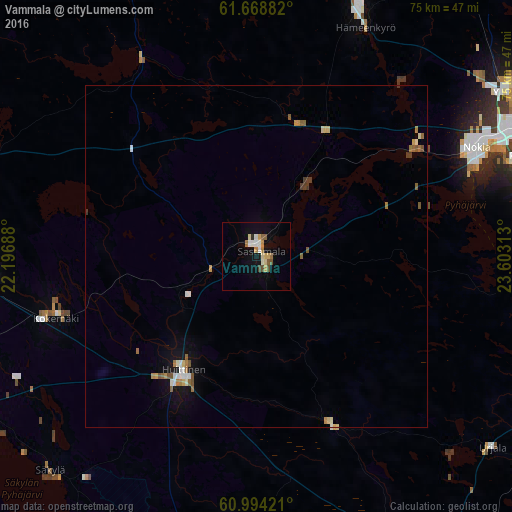
Analysis of Vammala night lights 2016
Square area 10x10 km:
 0.59%
0.59%90-99
2.17%80-89
1.98%70-79
1.58%60-69
1.28%50-59
1.38%40-49
1.09%30-39
0.2%20-29
0.4%10-19
3.75%0-9
85.57%Square area 50x50 km:
0.14%90-99
0.27%80-89
0.2%70-79
0.2%60-69
0.24%50-59
0.36%40-49
0.09%30-39
0.16%20-29
0.02%10-19
0.65%0-9
97.66%Clear (daylight) street map image can be seen on geolist.org.
Map coordinates:
61° 40' 7.8" North, 22° 11' 48.8" East
61° 19' 60" North, 22° 54' 0" East
60° 59' 39.2" North, 23° 36' 11.3" East
Some cities around Vammala sort by population:
• Nokia
35.2 km =21.9 mi,  65°
65°
• Ylöjärvi
44.5 km =27.7 mi,  56°
56°
• Pirkkala
41.5 km =25.8 mi, 69°
• Hämeenkyrö
37.4 km =23.2 mi,  24°
24°
• Huittinen
19.8 km =12.3 mi,  212°
212°
• Kokemäki
30.3 km =18.8 mi,  253°
253°
• Harjavalta
40.9 km =25.4 mi,  267°
267°
• Urjala
43.9 km =27.3 mi,  129°
129°
632542 (p: 14,982)
Sources (retrieved 2019-11-25):
» Earth at Night: Flat Maps 2012, 2016