Teuva night lights from space
Night Light of Teuva (Southern Ostrobothnia) from space (Finland) Src. Average luminocity for 10x10km area is 1.3053% and for 50x50km: 4.5146%.
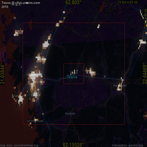
Analysis of Teuva night lights 2016
Square area 10x10 km:
 0%
0%90-99
0%80-89
0.4%70-79
0%60-69
0.79%50-59
0%40-49
0.79%30-39
0%20-29
0%10-19
0%0-9
98.02%Square area 50x50 km:
0.73%90-99
0.75%80-89
0.23%70-79
0.34%60-69
0.38%50-59
0.65%40-49
0.98%30-39
0.95%20-29
0.91%10-19
3.49%0-9
90.59%Clear (daylight) street map image can be seen on geolist.org.
Map coordinates:
62° 48' 18" North, 21° 2' 18.4" East
62° 28' 54.8" North, 21° 44' 29.6" East
62° 9' 18.9" North, 22° 26' 40.9" East
Some cities around Teuva sort by population:
• Kauhajoki
23.3 km =14.5 mi,  103°
103°
• Ilmajoki
50.6 km =31.4 mi,  56°
56°
• Kurikka
37.7 km =23.4 mi,  66°
66°
• Jalasjärvi
51.8 km =32.2 mi,  87°
87°
• Laihia
56.6 km =35.2 mi,  14°
14°
• Kristinestad
29.8 km =18.5 mi,  219°
219°
• Ylistaro
64.3 km =40 mi,  37°
37°
• Malax
51.9 km =32.2 mi,  350°
350°
634561 (p: 6,092)
Sources (retrieved 2019-11-25):
» Earth at Night: Flat Maps 2012, 2016