Leppävirta night lights from space
Night Light of Leppävirta (Northern Savonia) from space (Finland) Src. Average luminocity for 10x10km area is 19.9644% and for 50x50km: 4.7629%.
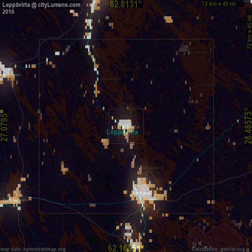
Analysis of Leppävirta night lights 2016
Square area 10x10 km:
 3.85%
3.85%90-99
3.85%80-89
1.09%70-79
1.78%60-69
5.93%50-59
0.3%40-49
0.2%30-39
0%20-29
0.49%10-19
27.47%0-9
55.04%Square area 50x50 km:
0.66%90-99
0.86%80-89
0.38%70-79
0.62%60-69
0.83%50-59
0.42%40-49
0.29%30-39
0.7%20-29
1.35%10-19
3.57%0-9
90.32%Clear (daylight) street map image can be seen on geolist.org.
Map coordinates:
62° 48' 47.2" North, 27° 4' 46.2" East
62° 29' 24.3" North, 27° 46' 57.4" East
62° 9' 48.7" North, 28° 29' 8.7" East
Some cities around Leppävirta sort by population:
• Kuopio
45.1 km =28 mi,  353°
353°
• Varkaus
20 km =12.4 mi,  166°
166°
• Siilinjärvi
66.2 km =41.1 mi, 354°
• Pieksämäki
39.6 km =24.6 mi,  237°
237°
• Outokumpu
68.4 km =42.5 mi,  67°
67°
• Suonenjoki
36.1 km =22.4 mi,  292°
292°
• Juva
65.7 km =40.8 mi,  176°
176°
• Joroinen
34.8 km =21.6 mi, 175°
648227 (p: 10,936)
Sources (retrieved 2019-11-25):
» Earth at Night: Flat Maps 2012, 2016