Villanueva del Trabuco night lights from space
Night Light of Villanueva del Trabuco (Andalusia) from space (Spain) Src. Average luminocity for 10x10km area is 8.4167% and for 50x50km: 3.912%.
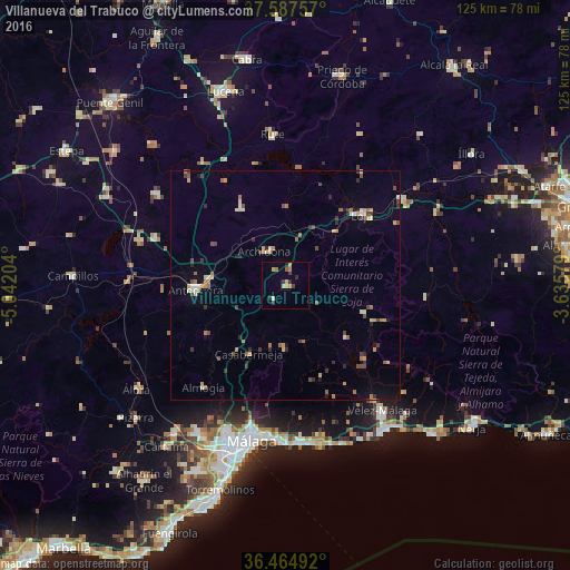
Analysis of Villanueva del Trabuco night lights 2016
Square area 10x10 km:
 0%
0%90-99
0.34%80-89
1.53%70-79
3.23%60-69
1.02%50-59
0.68%40-49
0.51%30-39
2.72%20-29
2.21%10-19
0%0-9
87.76%Square area 50x50 km:
0.14%90-99
0.41%80-89
0.5%70-79
0.67%60-69
0.69%50-59
0.37%40-49
0.71%30-39
0.76%20-29
0.64%10-19
0.72%0-9
94.38%Clear (daylight) street map image can be seen on geolist.org.
Map coordinates:
37° 35' 15.3" North, 5° 2' 31.3" West
37° 1' 42" North, 4° 20' 20.1" West
36° 27' 53.7" North, 3° 38' 8.8" West
Some cities around Villanueva del Trabuco sort by population:
• Vélez-Málaga
34.6 km =21.5 mi,  142°
142°
• Antequera
19.8 km =12.3 mi,  267°
267°
• Loja
22.8 km =14.2 mi,  46°
46°
• Valdés
31.2 km =19.4 mi,  164°
164°
• Rute
33.3 km =20.7 mi,  355°
355°
• Huétor-Tájar
32.1 km =19.9 mi, 53°
• Archidona
8.8 km =5.5 mi,  329°
329°
• Alhama de Granada
31.1 km =19.3 mi,  94°
94°
2509543 (p: 5,067)
Sources (retrieved 2019-11-25):
» Earth at Night: Flat Maps 2012, 2016