Villacarrillo night lights from space
Night Light of Villacarrillo (Andalusia) from space (Spain) Src. Average luminocity for 10x10km area is 8.4399% and for 50x50km: 2.3456%.
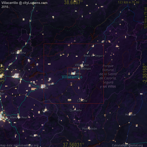
Analysis of Villacarrillo night lights 2016
Square area 10x10 km:
 1.3%
1.3%90-99
1.95%80-89
0.32%70-79
1.14%60-69
1.3%50-59
0.81%40-49
0.65%30-39
1.3%20-29
0.65%10-19
0.49%0-9
90.1%Square area 50x50 km:
0.19%90-99
0.47%80-89
0.36%70-79
0.18%60-69
0.35%50-59
0.28%40-49
0.28%30-39
0.36%20-29
0.4%10-19
0.39%0-9
96.75%Clear (daylight) street map image can be seen on geolist.org.
Map coordinates:
38° 40' 0.1" North, 3° 47' 16.5" West
38° 6' 56.2" North, 3° 5' 5.3" West
37° 33' 37.1" North, 2° 22' 54" West
Some cities around Villacarrillo sort by population:
• Campiña
14.7 km =9.1 mi,  38°
38°
• Úbeda
27.5 km =17.1 mi,  245°
245°
• Cazorla
23.4 km =14.5 mi,  162°
162°
• Torreperogil
20.1 km =12.5 mi,  243°
243°
• Quesada
30.3 km =18.8 mi,  176°
176°
• Peal de Becerro
22.7 km =14.1 mi,  188°
188°
• Beas de Segura
22.9 km =14.2 mi,  48°
48°
• Navas de San Juan
21.6 km =13.4 mi,  290°
290°
2509606 (p: 11,294)
Sources (retrieved 2019-11-25):
» Earth at Night: Flat Maps 2012, 2016