Vícar night lights from space
Night Light of Vícar (Andalusia) from space (Spain) Src. Average luminocity for 10x10km area is 30.9821% and for 50x50km: 11.0943%.
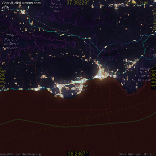

Analysis of Vícar night lights 2016
Square area 10x10 km:
 2.6%
2.6%90-99
7.63%80-89
4.71%70-79
3.25%60-69
6.66%50-59
1.79%40-49
2.6%30-39
4.55%20-29
8.28%10-19
24.35%0-9
33.6%Square area 50x50 km:
1.39%90-99
2.23%80-89
1.21%70-79
1.01%60-69
1.76%50-59
0.74%40-49
0.85%30-39
1.56%20-29
4.16%10-19
10.16%0-9
74.93%Clear (daylight) street map image can be seen on geolist.org.
Map coordinates:
37° 23' 32.1" North, 3° 20' 45.1" West
36° 49' 53.6" North, 2° 38' 33.8" West
36° 16' 0.1" North, 1° 56' 22.6" West
Some cities around Vícar sort by population:
• Almería
16.3 km =10.1 mi,  87°
87°
• El Ejido
16.5 km =10.3 mi,  248°
248°
• Roquetas de Mar
7.9 km =4.9 mi,  161°
161°
• Adra
34.9 km =21.7 mi, 254°
• Berja
27.4 km =17 mi,  273°
273°
• Huércal de Almería
19.2 km =11.9 mi,  71°
71°
• Aguadulce
6.6 km =4.1 mi,  107°
107°
• La Gangosa Vistasol
3.4 km =2.1 mi,  146°
146°
2509650 (p: 22,853)
Sources (retrieved 2019-11-25):
» Earth at Night: Flat Maps 2012, 2016