Huércal de Almería night lights from space
Night Light of Huércal de Almería (Andalusia) from space (Spain) Src. Average luminocity for 10x10km area is 52.8377% and for 50x50km: 9.7403%.
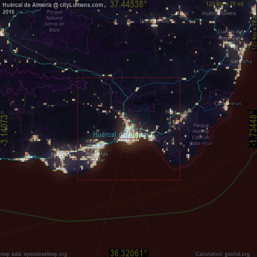
Analysis of Huércal de Almería night lights 2016
Square area 10x10 km:
 10.55%
90-99
12.18%80-89
6.66%70-79
6.82%60-69
8.28%50-59
4.71%40-49
5.03%30-39
7.14%20-29
15.75%10-19
21.1%0-9
1.79%Square area 50x50 km:
1.18%90-99
1.82%80-89
1.16%70-79
0.92%60-69
1.4%50-59
0.72%40-49
0.89%30-39
1.57%20-29
3.21%10-19
8.51%0-9
78.64%Clear (daylight) street map image can be seen on geolist.org.
Map coordinates:
37° 26' 43.4" North, 3° 8' 26.6" West
36° 53' 6.3" North, 2° 26' 15.4" West
36° 19' 14.2" North, 1° 44' 4.1" West
Some cities around Huércal de Almería sort by population:
• Almería
5.6 km =3.5 mi,  200°
200°
• El Ejido
35.7 km =22.2 mi,  250°
250°
• Roquetas de Mar
20.7 km =12.9 mi,  229°
229°
• Níjar
22.5 km =14 mi,  66°
66°
• Vícar
19.2 km =11.9 mi, 251°
• Aguadulce
14.4 km =8.9 mi,  236°
236°
• La Gangosa Vistasol
18.6 km =11.6 mi, 241°
• La Mojonera
45.3 km =28.1 mi,  0°
0°
2516543 (p: 14,937)
Sources (retrieved 2019-11-25):
» Earth at Night: Flat Maps 2012, 2016