Velilla de San Antonio night lights from space
Night Light of Velilla de San Antonio (Madrid) from space (Spain) Src. Average luminocity for 10x10km area is 53.1361% and for 50x50km: 43.7023%.
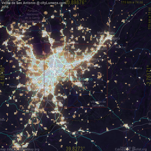
Analysis of Velilla de San Antonio night lights 2016
Square area 10x10 km:
 7.48%
7.48%90-99
10.37%80-89
5.27%70-79
7.65%60-69
7.31%50-59
8.84%40-49
10.71%30-39
14.97%20-29
23.98%10-19
3.4%0-9
0%Square area 50x50 km:
13.01%90-99
10.37%80-89
3.82%70-79
5.03%60-69
4.31%50-59
4.17%40-49
4.17%30-39
5.75%20-29
9.34%10-19
11.65%0-9
28.38%Clear (daylight) street map image can be seen on geolist.org.
Map coordinates:
40° 53' 55.5" North, 4° 11' 16.7" West
40° 21' 54.6" North, 3° 29' 5.4" West
39° 49' 38.3" North, 2° 46' 54.2" West
Some cities around Velilla de San Antonio sort by population:
• Torrejón de Ardoz
10.1 km =6.3 mi,  7°
7°
• Coslada
9.2 km =5.7 mi,  315°
315°
• Rivas-Vaciamadrid
4.9 km =3 mi,  206°
206°
• Vicálvaro
10.5 km =6.5 mi,  291°
291°
• Villa de Vallecas
9.9 km =6.2 mi,  271°
271°
• Arganda
8.2 km =5.1 mi,  150°
150°
• San Fernando de Henares
7.7 km =4.8 mi,  328°
328°
• Mejorada del Campo
3.1 km =1.9 mi,  4°
4°
3106202 (p: 11,553)
Sources (retrieved 2019-11-25):
» Earth at Night: Flat Maps 2012, 2016