Torreblanca night lights from space
Night Light of Torreblanca (Valencia) from space (Spain) Src. Average luminocity for 10x10km area is 10.2841% and for 50x50km: 6.3451%.
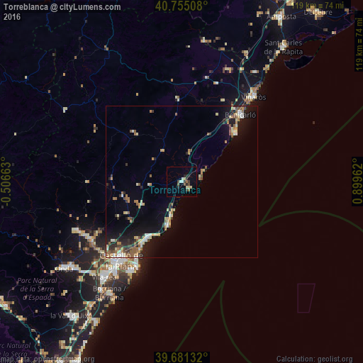
Analysis of Torreblanca night lights 2016
Square area 10x10 km:
 0.81%
0.81%90-99
1.14%80-89
1.95%70-79
0%60-69
1.14%50-59
1.79%40-49
1.62%30-39
1.46%20-29
4.38%10-19
0%0-9
85.71%Square area 50x50 km:
0.56%90-99
0.72%80-89
1.12%70-79
0.61%60-69
0.88%50-59
1.19%40-49
0.62%30-39
0.85%20-29
1.41%10-19
4.61%0-9
87.42%Clear (daylight) street map image can be seen on geolist.org.
Map coordinates:
40° 45' 18.3" North, 0° 30' 23.9" West
40° 13' 13.2" North, 0° 11' 47.4" East
39° 40' 52.8" North, 0° 53' 58.6" East
Some cities around Torreblanca sort by population:
• Castelló de la Plana
33.4 km =20.8 mi,  218°
218°
• Vinaròs
36.5 km =22.7 mi,  40°
40°
• Benicarló
29.3 km =18.2 mi, 41°
• Benicàssim
21.9 km =13.6 mi,  210°
210°
• El Grao
31.6 km =19.6 mi, 209°
• Oropesa del Mar
15.1 km =9.4 mi,  198°
198°
• Alcalà de Xivert
9.4 km =5.8 mi,  19°
19°
• Peníscola
23.5 km =14.6 mi,  49°
49°
3107849 (p: 5,626)
Sources (retrieved 2019-11-25):
» Earth at Night: Flat Maps 2012, 2016