Peníscola night lights from space
Night Light of Peníscola (Valencia) from space (Spain) Src. Average luminocity for 10x10km area is 15.9439% and for 50x50km: 4.1427%.
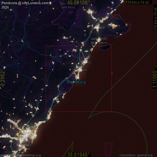
Analysis of Peníscola night lights 2016
Square area 10x10 km:
 1.36%
1.36%90-99
1.36%80-89
2.38%70-79
3.23%60-69
1.19%50-59
2.72%40-49
1.53%30-39
1.19%20-29
1.36%10-19
20.92%0-9
62.76%Square area 50x50 km:
0.27%90-99
0.45%80-89
0.71%70-79
0.5%60-69
0.46%50-59
0.81%40-49
0.4%30-39
0.51%20-29
0.55%10-19
3.24%0-9
92.09%Clear (daylight) street map image can be seen on geolist.org.
Map coordinates:
40° 53' 27.8" North, 0° 17' 46.3" West
40° 21' 26.6" North, 0° 24' 24.9" East
39° 49' 10.1" North, 1° 6' 36.2" East
Some cities around Peníscola sort by population:
• Vinaròs
13.8 km =8.6 mi,  24°
24°
• Benicarló
6.8 km =4.2 mi,  14°
14°
• Sant Carles de la Ràpita
33.1 km =20.6 mi,  29°
29°
• Oropesa del Mar
37.2 km =23.1 mi,  217°
217°
• Alcanar
21.6 km =13.4 mi, 16°
• Alcalà de Xivert
16 km =9.9 mi,  246°
246°
• Ulldecona
26.9 km =16.7 mi, 7°
• Torreblanca
23.5 km =14.6 mi,  229°
229°
3113860 (p: 6,006)
Sources (retrieved 2019-11-25):
» Earth at Night: Flat Maps 2012, 2016