Benicàssim night lights from space
Night Light of Benicàssim (Valencia) from space (Spain) Src. Average luminocity for 10x10km area is 26.5276% and for 50x50km: 12.5033%.
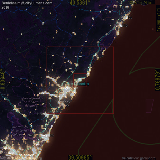
Analysis of Benicàssim night lights 2016
Square area 10x10 km:
 3.57%
3.57%90-99
3.08%80-89
5.68%70-79
2.6%60-69
2.11%50-59
3.73%40-49
1.95%30-39
2.11%20-29
5.19%10-19
37.99%0-9
31.98%Square area 50x50 km:
1.55%90-99
1.92%80-89
1.7%70-79
1.36%60-69
1.68%50-59
1.85%40-49
1.23%30-39
1.78%20-29
4.12%10-19
10.09%0-9
72.74%Clear (daylight) street map image can be seen on geolist.org.
Map coordinates:
40° 35' 10" North, 0° 38' 11.3" West
40° 3' 0" North, 0° 4' 0" East
39° 30' 34.7" North, 0° 46' 11.2" East
Some cities around Benicàssim sort by population:
• Castelló de la Plana
12.2 km =7.6 mi,  234°
234°
• Vila-real
18.9 km =11.7 mi, 228°
• Burriana
22.1 km =13.7 mi,  215°
215°
• Almassora
15.9 km =9.9 mi, 224°
• El Grao
9.7 km =6 mi,  208°
208°
• Oropesa del Mar
7.8 km =4.8 mi,  54°
54°
• l'Alcora
22.8 km =14.2 mi,  274°
274°
• Torreblanca
21.9 km =13.6 mi,  30°
30°
3128272 (p: 18,098)
Sources (retrieved 2019-11-25):
» Earth at Night: Flat Maps 2012, 2016