Sopela night lights from space
Night Light of Sopela (Basque Country) from space (Spain) Src. Average luminocity for 10x10km area is 53.054% and for 50x50km: 18.1444%.
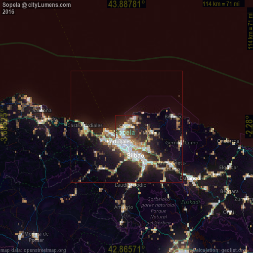
Analysis of Sopela night lights 2016
Square area 10x10 km:
 11.27%
90-99
12.7%80-89
3.81%70-79
4.6%60-69
5.24%50-59
9.84%40-49
7.78%30-39
13.97%20-29
15.71%10-19
12.38%0-9
2.7%Square area 50x50 km:
3.09%90-99
3.52%80-89
1.65%70-79
1.84%60-69
2.18%50-59
2.66%40-49
2.17%30-39
2.68%20-29
5.46%10-19
12.72%0-9
62.04%Clear (daylight) street map image can be seen on geolist.org.
Map coordinates:
43° 53' 16.1" North, 3° 41' 10.5" West
43° 22' 44.1" North, 2° 58' 59.3" West
42° 51' 56.6" North, 2° 16' 48" West
Some cities around Sopela sort by population:
• Algorta
3.9 km =2.4 mi,  212°
212°
• Getxo
3.4 km =2.1 mi,  223°
223°
• Portugalete
7.1 km =4.4 mi, 205°
• Santurtzi
6.9 km =4.3 mi, 215°
• Leioa
5.8 km =3.6 mi,  184°
184°
• Sestao
7.9 km =4.9 mi,  194°
194°
• Erandio
8.3 km =5.2 mi,  174°
174°
• Berango
1.9 km =1.2 mi, 213°
3108702 (p: 12,359)
Sources (retrieved 2019-11-25):
» Earth at Night: Flat Maps 2012, 2016