Berango night lights from space
Night Light of Berango (Basque Country) from space (Spain) Src. Average luminocity for 10x10km area is 60.4508% and for 50x50km: 18.2904%.
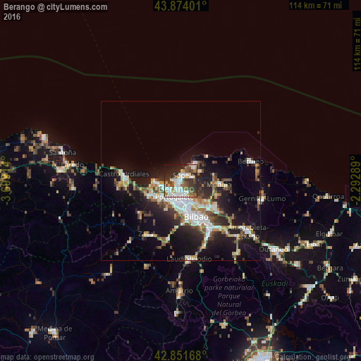
Analysis of Berango night lights 2016
Square area 10x10 km:
100  14.76%
90-99 15.56%
80-89 4.44%
70-79 6.19%
60-69 6.98%
50-59 10.48%
40-49 7.46%
30-39 12.22%
20-29 13.49%
10-19 7.94%
0-9 0.48%
14.76%90-99
15.56%80-89
4.44%70-79
6.19%60-69
6.98%50-59
10.48%40-49
7.46%30-39
12.22%20-29
13.49%10-19
7.94%0-9
0.48%Square area 50x50 km:
100 3.11%
90-99 3.54%
80-89 1.66%
70-79 1.84%
60-69 2.19%
50-59 2.72%
40-49 2.17%
30-39 2.71%
20-29 5.49%
10-19 12.71%
0-9 61.86%
3.11%90-99
3.54%80-89
1.66%70-79
1.84%60-69
2.19%50-59
2.72%40-49
2.17%30-39
2.71%20-29
5.49%10-19
12.71%0-9
61.86%Clear (daylight) street map image can be seen on geolist.org.
Map coordinates:
43° 52' 26.4" North, 3° 41' 56.9" West
43° 21' 54" North, 2° 59' 45.6" West
42° 51' 6" North, 2° 17' 34.4" West
Some cities around Berango sort by population:
• Algorta
2.1 km =1.3 mi,  211°
211°
• Getxo
1.5 km =0.9 mi,  234°
234°
• Portugalete
5.3 km =3.3 mi,  202°
202°
• Santurtzi
5 km =3.1 mi,  215°
215°
• Leioa
4.3 km =2.7 mi,  172°
172°
• Sestao
6.2 km =3.9 mi,  188°
188°
• Erandio
7 km =4.3 mi,  164°
164°
• Sopela
1.9 km =1.2 mi,  33°
33°
3128248 (p: 6,064)
Sources (retrieved 2019-11-25):
» Earth at Night: Flat Maps 2012, 2016