Santafé night lights from space
Night Light of Santafé (Andalusia) from space (Spain) Src. Average luminocity for 10x10km area is 43.3571% and for 50x50km: 12.3218%.
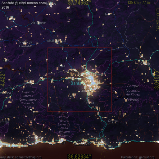
Analysis of Santafé night lights 2016
Square area 10x10 km:
 3.06%
3.06%90-99
8.33%80-89
4.59%70-79
5.61%60-69
12.24%50-59
6.46%40-49
6.8%30-39
6.46%20-29
17.86%10-19
22.28%0-9
6.29%Square area 50x50 km:
1.23%90-99
2.08%80-89
1.68%70-79
1.68%60-69
2.76%50-59
1.68%40-49
1.26%30-39
1.49%20-29
3.38%10-19
6.87%0-9
75.89%Clear (daylight) street map image can be seen on geolist.org.
Map coordinates:
37° 44' 47.8" North, 4° 25' 19.2" West
37° 11' 18.8" North, 3° 43' 7.9" West
36° 37' 34.8" North, 3° 0' 56.7" West
Some cities around Santafé sort by population:
• Maracena
7.7 km =4.8 mi,  74°
74°
• Albolote
7.4 km =4.6 mi,  50°
50°
• Las Gabias
7.3 km =4.5 mi,  143°
143°
• Atarfe
4.9 km =3 mi,  35°
35°
• Pinos Puente
7.5 km =4.7 mi,  338°
338°
• Churriana de la Vega
8.1 km =5 mi,  126°
126°
• Peligros
9.3 km =5.8 mi,  58°
58°
• Cúllar-Vega
5.8 km =3.6 mi, 132°
2511160 (p: 15,430)
Sources (retrieved 2019-11-25):
» Earth at Night: Flat Maps 2012, 2016