Atarfe night lights from space
Night Light of Atarfe (Andalusia) from space (Spain) Src. Average luminocity for 10x10km area is 51.2415% and for 50x50km: 11.9974%.
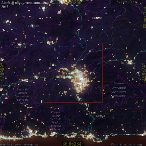
Analysis of Atarfe night lights 2016
Square area 10x10 km:
 7.48%
7.48%90-99
11.73%80-89
3.4%70-79
4.42%60-69
13.44%50-59
9.52%40-49
6.63%30-39
7.65%20-29
20.41%10-19
15.31%0-9
0%Square area 50x50 km:
1.21%90-99
2%80-89
1.67%70-79
1.65%60-69
2.7%50-59
1.56%40-49
1.16%30-39
1.44%20-29
3.36%10-19
6.72%0-9
76.53%Clear (daylight) street map image can be seen on geolist.org.
Map coordinates:
37° 46' 57.3" North, 4° 23' 24" West
37° 13' 29.2" North, 3° 41' 12.7" West
36° 39' 46.2" North, 2° 59' 1.5" West
Some cities around Atarfe sort by population:
• Granada
8.2 km =5.1 mi,  119°
119°
• Maracena
5 km =3.1 mi,  112°
112°
• Albolote
2.9 km =1.8 mi,  76°
76°
• Santafé
4.9 km =3 mi,  215°
215°
• Pinos Puente
6.3 km =3.9 mi,  297°
297°
• Churriana de la Vega
9.6 km =6 mi,  157°
157°
• Peligros
5.2 km =3.2 mi, 80°
• Cúllar-Vega
8 km =5 mi,  169°
169°
2521485 (p: 15,399)
Sources (retrieved 2019-11-25):
» Earth at Night: Flat Maps 2012, 2016