Albolote night lights from space
Night Light of Albolote (Andalusia) from space (Spain) Src. Average luminocity for 10x10km area is 58.7925% and for 50x50km: 11.9626%.
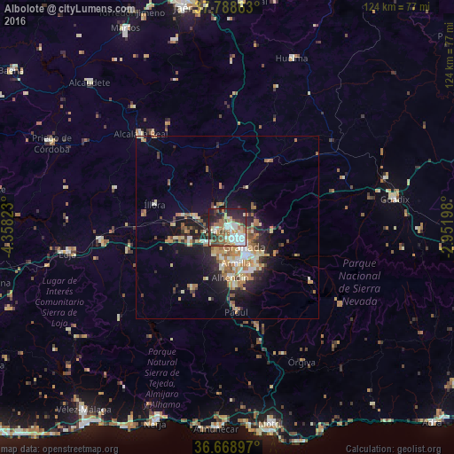
Analysis of Albolote night lights 2016
Square area 10x10 km:
 12.76%
90-99
14.8%80-89
5.27%70-79
4.76%60-69
13.1%50-59
6.29%40-49
6.97%30-39
8.5%20-29
18.37%10-19
9.18%0-9
0%Square area 50x50 km:
1.21%90-99
2.03%80-89
1.65%70-79
1.69%60-69
2.73%50-59
1.55%40-49
1.13%30-39
1.33%20-29
3.35%10-19
6.7%0-9
76.65%Clear (daylight) street map image can be seen on geolist.org.
Map coordinates:
37° 47' 19.1" North, 4° 21' 29.6" West
37° 13' 51.2" North, 3° 39' 18.4" West
36° 40' 8.3" North, 2° 57' 7.1" West
Some cities around Albolote sort by population:
• Granada
6.4 km =4 mi,  137°
137°
• Maracena
3.1 km =1.9 mi,  145°
145°
• Santafé
7.4 km =4.6 mi,  230°
230°
• Atarfe
2.9 km =1.8 mi,  256°
256°
• Pinos Puente
8.7 km =5.4 mi,  285°
285°
• Churriana de la Vega
9.6 km =6 mi,  175°
175°
• Peligros
2.3 km =1.4 mi,  86°
86°
• Cúllar-Vega
8.7 km =5.4 mi,  189°
189°
2522208 (p: 17,089)
Sources (retrieved 2019-11-25):
» Earth at Night: Flat Maps 2012, 2016