Sant Sadurní d'Anoia night lights from space
Night Light of Sant Sadurní d'Anoia (Catalonia) from space (Spain) Src. Average luminocity for 10x10km area is 34.119% and for 50x50km: 37.4659%.
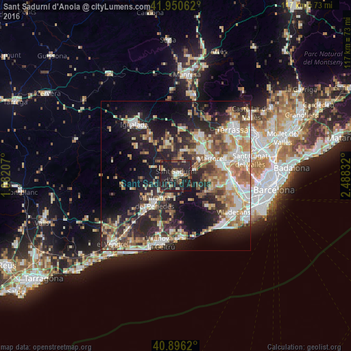
Analysis of Sant Sadurní d'Anoia night lights 2016
Square area 10x10 km:
 3.06%
3.06%90-99
4.42%80-89
4.08%70-79
2.04%60-69
2.21%50-59
4.93%40-49
5.95%30-39
6.97%20-29
30.95%10-19
35.37%0-9
0%Square area 50x50 km:
5.71%90-99
7.02%80-89
4.74%70-79
4.88%60-69
6.55%50-59
5.97%40-49
3.47%30-39
5.07%20-29
12.71%10-19
18.41%0-9
25.47%Clear (daylight) street map image can be seen on geolist.org.
Map coordinates:
41° 57' 2.2" North, 1° 4' 55.5" East
41° 25' 32" North, 1° 47' 6.7" East
40° 53' 46.3" North, 2° 29' 18" East
Some cities around Sant Sadurní d'Anoia sort by population:
• Vilafranca del Penedès
11.5 km =7.1 mi,  219°
219°
• Martorell
13.3 km =8.3 mi,  66°
66°
• Piera
11.1 km =6.9 mi,  345°
345°
• Vallirana
13 km =8.1 mi,  109°
109°
• Corbera de Llobregat
11.3 km =7 mi,  94°
94°
• Abrera
14 km =8.7 mi,  43°
43°
• Masquefa
8.9 km =5.5 mi,  14°
14°
• Gelida
6.8 km =4.2 mi,  82°
82°
3110064 (p: 12,237)
Sources (retrieved 2019-11-25):
» Earth at Night: Flat Maps 2012, 2016