Piera night lights from space
Night Light of Piera (Catalonia) from space (Spain) Src. Average luminocity for 10x10km area is 35.4932% and for 50x50km: 27.7066%.
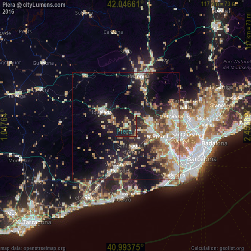
Analysis of Piera night lights 2016
Square area 10x10 km:
 0.34%
0.34%90-99
3.57%80-89
4.76%70-79
5.95%60-69
6.63%50-59
7.48%40-49
3.74%30-39
6.8%20-29
20.92%10-19
39.63%0-9
0.17%Square area 50x50 km:
3.78%90-99
4.81%80-89
3.45%70-79
3.44%60-69
4.84%50-59
4.4%40-49
2.78%30-39
3.91%20-29
9.59%10-19
17.17%0-9
41.83%Clear (daylight) street map image can be seen on geolist.org.
Map coordinates:
42° 2' 47.8" North, 1° 2' 51.5" East
41° 31' 20.4" North, 1° 45' 2.7" East
40° 59' 37.5" North, 2° 27' 14" East
Some cities around Piera sort by population:
• Igualada
12.9 km =8 mi,  300°
300°
• Olesa de Montserrat
12.2 km =7.6 mi,  78°
78°
• Esparreguera
10.1 km =6.3 mi, 80°
• Vilanova del Camí
10.9 km =6.8 mi, 300°
• Sant Sadurní d'Anoia
11.1 km =6.9 mi,  165°
165°
• Abrera
12.5 km =7.8 mi,  92°
92°
• Masquefa
5.5 km =3.4 mi,  112°
112°
• Capellades
5.4 km =3.4 mi,  279°
279°
3113576 (p: 14,324)
Sources (retrieved 2019-11-25):
» Earth at Night: Flat Maps 2012, 2016