Sant Celoni night lights from space
Night Light of Sant Celoni (Catalonia) from space (Spain) Src. Average luminocity for 10x10km area is 28.5584% and for 50x50km: 25.1967%.
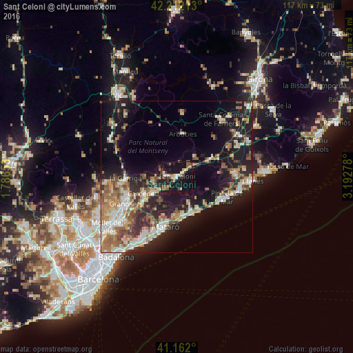
Analysis of Sant Celoni night lights 2016
Square area 10x10 km:
 2.6%
2.6%90-99
3.41%80-89
3.08%70-79
4.22%60-69
2.44%50-59
6.82%40-49
3.25%30-39
3.9%20-29
7.14%10-19
45.13%0-9
18.02%Square area 50x50 km:
3.18%90-99
4.41%80-89
3.37%70-79
3.05%60-69
4.1%50-59
3.85%40-49
3.05%30-39
3.26%20-29
6.85%10-19
18.67%0-9
46.21%Clear (daylight) street map image can be seen on geolist.org.
Map coordinates:
42° 12' 43.7" North, 1° 47' 11.5" East
41° 41' 21.2" North, 2° 29' 22.7" East
41° 9' 43.2" North, 3° 11' 34" East
Some cities around Sant Celoni sort by population:
• Mataró
16.8 km =10.4 mi,  192°
192°
• Calella
16 km =9.9 mi,  121°
121°
• Cardedeu
12.3 km =7.6 mi,  243°
243°
• Arenys de Mar
12.9 km =8 mi,  157°
157°
• Canet de Mar
13.3 km =8.3 mi,  145°
145°
• Argentona
16.8 km =10.4 mi,  205°
205°
• Santa Maria de Palautordera
3.7 km =2.3 mi,  278°
278°
• Arenys de Munt
9.3 km =5.8 mi, 153°
3110813 (p: 16,860)
Sources (retrieved 2019-11-25):
» Earth at Night: Flat Maps 2012, 2016