Canet de Mar night lights from space
Night Light of Canet de Mar (Catalonia) from space (Spain) Src. Average luminocity for 10x10km area is 28.7857% and for 50x50km: 17.6519%.
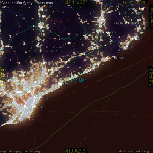
Analysis of Canet de Mar night lights 2016
Square area 10x10 km:
 2.44%
2.44%90-99
6.17%80-89
6.82%70-79
3.25%60-69
2.27%50-59
1.14%40-49
1.3%30-39
2.44%20-29
5.52%10-19
46.59%0-9
22.08%Square area 50x50 km:
1.92%90-99
2.84%80-89
2.37%70-79
1.81%60-69
2.09%50-59
2.9%40-49
2.2%30-39
2.9%20-29
6.71%10-19
15.93%0-9
58.34%Clear (daylight) street map image can be seen on geolist.org.
Map coordinates:
42° 6' 51.4" North, 1° 52' 40.9" East
41° 35' 25.9" North, 2° 34' 52.2" East
41° 3' 45.1" North, 3° 17' 3.4" East
Some cities around Canet de Mar sort by population:
• Mataró
12.6 km =7.8 mi,  244°
244°
• Pineda de Mar
9.9 km =6.2 mi,  65°
65°
• Calella
6.6 km =4.1 mi, 66°
• Arenys de Mar
2.8 km =1.7 mi,  250°
250°
• Sant Andreu de Llavaneres
8.6 km =5.3 mi, 251°
• Arenys de Munt
4.3 km =2.7 mi,  307°
307°
• Sant Vicenç de Montalt
6.2 km =3.9 mi,  257°
257°
• Sant Pol de Mar
3.3 km =2.1 mi, 67°
3126584 (p: 14,123)
Sources (retrieved 2019-11-25):
» Earth at Night: Flat Maps 2012, 2016