Sant Andreu de Llavaneres night lights from space
Night Light of Sant Andreu de Llavaneres (Catalonia) from space (Spain) Src. Average luminocity for 10x10km area is 43.6224% and for 50x50km: 24.61%.
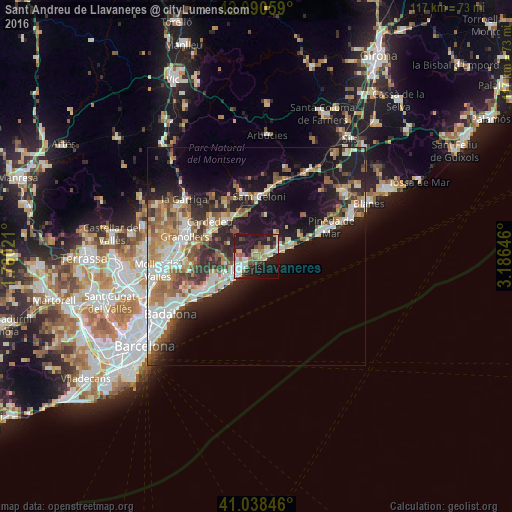
Analysis of Sant Andreu de Llavaneres night lights 2016
Square area 10x10 km:
 5.95%
5.95%90-99
9.86%80-89
4.59%70-79
5.44%60-69
6.29%50-59
5.27%40-49
4.08%30-39
6.12%20-29
21.6%10-19
27.21%0-9
3.57%Square area 50x50 km:
4.1%90-99
4.6%80-89
3.01%70-79
2.81%60-69
3.66%50-59
3.78%40-49
3.07%30-39
3.14%20-29
6.74%10-19
14.5%0-9
50.59%Clear (daylight) street map image can be seen on geolist.org.
Map coordinates:
42° 5' 26.1" North, 1° 46' 48.8" East
41° 34' 0" North, 2° 28' 60" East
41° 2' 18.5" North, 3° 11' 11.3" East
Some cities around Sant Andreu de Llavaneres sort by population:
• Mataró
4.2 km =2.6 mi,  229°
229°
• Vilassar de Mar
10.2 km =6.3 mi, 227°
• Arenys de Mar
5.7 km =3.5 mi,  72°
72°
• Canet de Mar
8.6 km =5.3 mi, 71°
• Argentona
7 km =4.3 mi,  257°
257°
• La Roca del Vallès
12.6 km =7.8 mi,  278°
278°
• Arenys de Munt
7.1 km =4.4 mi,  41°
41°
• Cabrils
10.4 km =6.5 mi,  245°
245°
3110881 (p: 10,181)
Sources (retrieved 2019-11-25):
» Earth at Night: Flat Maps 2012, 2016