Cabrils night lights from space
Night Light of Cabrils (Catalonia) from space (Spain) Src. Average luminocity for 10x10km area is 59.5238% and for 50x50km: 33.5494%.
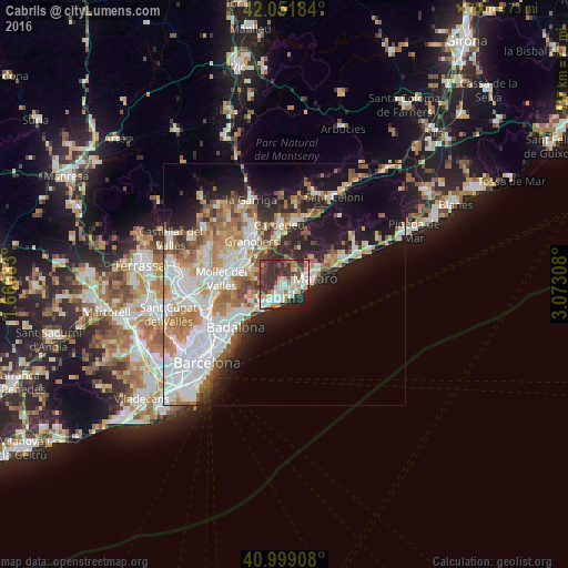
Analysis of Cabrils night lights 2016
Square area 10x10 km:
 12.76%
90-99
14.63%80-89
7.14%70-79
5.95%60-69
6.12%50-59
5.1%40-49
9.69%30-39
20.58%20-29
14.63%10-19
3.4%0-9
0%Square area 50x50 km:
8.54%90-99
7.59%80-89
3.45%70-79
3.77%60-69
4.97%50-59
4.11%40-49
3.13%30-39
3.27%20-29
6.1%10-19
12.4%0-9
42.67%Clear (daylight) street map image can be seen on geolist.org.
Map coordinates:
42° 3' 6.6" North, 1° 40' 0.6" East
41° 31' 39.4" North, 2° 22' 11.9" East
40° 59' 56.7" North, 3° 4' 23.1" East
Some cities around Cabrils sort by population:
• Mataró
6.4 km =4 mi,  75°
75°
• Premià de Mar
4 km =2.5 mi,  185°
185°
• El Masnou
6.8 km =4.2 mi,  218°
218°
• Vilassar de Mar
3.1 km =1.9 mi,  143°
143°
• Argentona
3.9 km =2.4 mi,  42°
42°
• La Roca del Vallès
6.9 km =4.3 mi,  333°
333°
• Alella
7.3 km =4.5 mi,  239°
239°
• Teià
5.2 km =3.2 mi,  230°
230°
3127147 (p: 6,306)
Sources (retrieved 2019-11-25):
» Earth at Night: Flat Maps 2012, 2016