Puçol night lights from space
Night Light of Puçol (Valencia) from space (Spain) Src. Average luminocity for 10x10km area is 51.7825% and for 50x50km: 26.5838%.
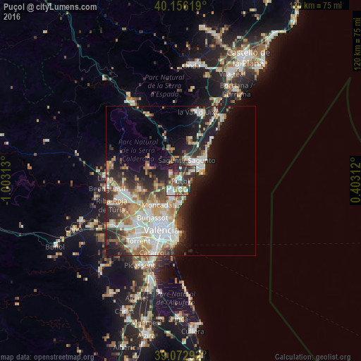
Analysis of Puçol night lights 2016
Square area 10x10 km:
 9.09%
9.09%90-99
11.04%80-89
3.57%70-79
7.63%60-69
5.36%50-59
8.44%40-49
9.9%30-39
8.28%20-29
26.14%10-19
10.23%0-9
0.32%Square area 50x50 km:
6.11%90-99
5.79%80-89
2.56%70-79
3.14%60-69
3.94%50-59
2.84%40-49
2.86%30-39
3.31%20-29
7.16%10-19
10.04%0-9
52.25%Clear (daylight) street map image can be seen on geolist.org.
Map coordinates:
40° 9' 22.3" North, 1° 0' 11.3" West
39° 37' 0" North, 0° 18' 0" West
39° 4' 22.5" North, 0° 24' 11.2" East
Some cities around Puçol sort by population:
• Sagunto
7.9 km =4.9 mi,  21°
21°
• Grao de Murviedro
5.9 km =3.7 mi,  62°
62°
• Moncada
11.4 km =7.1 mi,  225°
225°
• Massamagrell
6.3 km =3.9 mi,  207°
207°
• Meliana
9.7 km =6 mi,  197°
197°
• Puig
3.1 km =1.9 mi,  185°
185°
• La Pobla de Farnals
5.8 km =3.6 mi,  166°
166°
• Foios
10.2 km =6.3 mi, 204°
2512127 (p: 19,018)
Sources (retrieved 2019-11-25):
» Earth at Night: Flat Maps 2012, 2016