Massamagrell night lights from space
Night Light of Massamagrell (Valencia) from space (Spain) Src. Average luminocity for 10x10km area is 65.1786% and for 50x50km: 28.1678%.
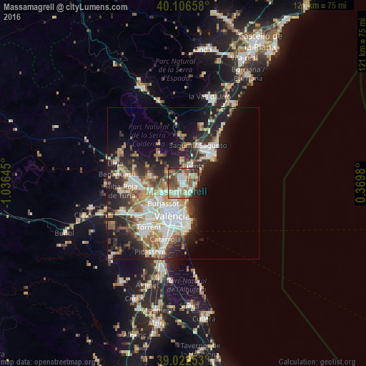
Analysis of Massamagrell night lights 2016
Square area 10x10 km:
 11.36%
90-99
13.31%80-89
7.79%70-79
10.88%60-69
12.5%50-59
13.47%40-49
12.82%30-39
8.12%20-29
8.93%10-19
0.81%0-9
0%Square area 50x50 km:
6.15%90-99
5.85%80-89
2.69%70-79
3.33%60-69
4.21%50-59
3.42%40-49
3.22%30-39
3.77%20-29
8.08%10-19
11.98%0-9
47.31%Clear (daylight) street map image can be seen on geolist.org.
Map coordinates:
40° 6' 23.7" North, 1° 2' 11.2" West
39° 34' 0" North, 0° 19' 60" West
39° 1' 21.1" North, 0° 22' 11.3" East
Some cities around Massamagrell sort by population:
• Alboraya
7.5 km =4.7 mi,  190°
190°
• Moncada
5.8 km =3.6 mi,  246°
246°
• Puçol
6.3 km =3.9 mi,  27°
27°
• Meliana
3.7 km =2.3 mi,  180°
180°
• Puig
3.6 km =2.2 mi,  46°
46°
• La Pobla de Farnals
4.2 km =2.6 mi,  91°
91°
• Rocafort
6.8 km =4.2 mi,  237°
237°
• Foios
4 km =2.5 mi,  201°
201°
2514066 (p: 15,210)
Sources (retrieved 2019-11-25):
» Earth at Night: Flat Maps 2012, 2016