Padul night lights from space
Night Light of Padul (Andalusia) from space (Spain) Src. Average luminocity for 10x10km area is 11.398% and for 50x50km: 11.0267%.
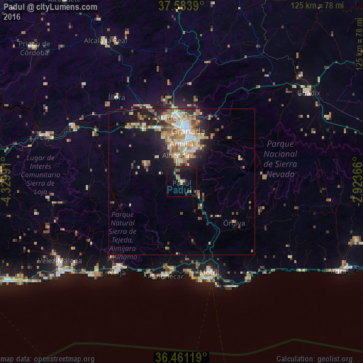
Analysis of Padul night lights 2016
Square area 10x10 km:
100  0%
0%
90-99 0%
80-89 0.68%
70-79 1.36%
60-69 2.55%
50-59 2.55%
40-49 2.89%
30-39 0.85%
20-29 2.04%
10-19 15.99%
0-9 71.09%
0%90-99
0%80-89
0.68%70-79
1.36%60-69
2.55%50-59
2.55%40-49
2.89%30-39
0.85%20-29
2.04%10-19
15.99%0-9
71.09%Square area 50x50 km:
100 1.21%
90-99 1.97%
80-89 1.46%
70-79 1.56%
60-69 2.52%
50-59 1.55%
40-49 1.2%
30-39 1.29%
20-29 2.8%
10-19 5.25%
0-9 79.19%
1.21%90-99
1.97%80-89
1.46%70-79
1.56%60-69
2.52%50-59
1.55%40-49
1.2%30-39
1.29%20-29
2.8%10-19
5.25%0-9
79.19%Clear (daylight) street map image can be seen on geolist.org.
Map coordinates:
37° 35' 2" North, 4° 19' 47.7" West
37° 1' 28.6" North, 3° 37' 36.4" West
36° 27' 40.3" North, 2° 55' 25.2" West
Some cities around Padul sort by population:
• Armilla
13.3 km =8.3 mi,  0°
0°
• Zubia
11.2 km =7 mi,  19°
19°
• Las Gabias
12.9 km =8 mi,  342°
342°
• Ogíjares
10.6 km =6.6 mi,  9°
9°
• Churriana de la Vega
13.5 km =8.4 mi,  352°
352°
• Dúrcal
6.8 km =4.2 mi,  127°
127°
• Otura
7.1 km =4.4 mi,  355°
355°
• Gójar
9.1 km =5.7 mi, 11°
2513035 (p: 7,266)
Sources (retrieved 2019-11-25):
» Earth at Night: Flat Maps 2012, 2016