Ondarroa night lights from space
Night Light of Ondarroa (Basque Country) from space (Spain) Src. Average luminocity for 10x10km area is 7.8773% and for 50x50km: 7.5371%.
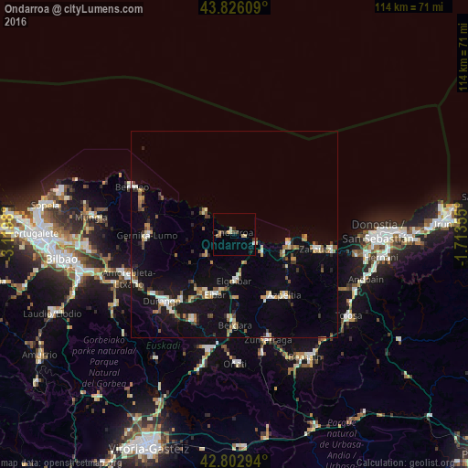
Analysis of Ondarroa night lights 2016
Square area 10x10 km:
100  0.45%
0.45%
90-99 1.36%
80-89 1.36%
70-79 0.45%
60-69 1.82%
50-59 0%
40-49 0.91%
30-39 1.21%
20-29 1.52%
10-19 0.61%
0-9 90.3%
0.45%90-99
1.36%80-89
1.36%70-79
0.45%60-69
1.82%50-59
0%40-49
0.91%30-39
1.21%20-29
1.52%10-19
0.61%0-9
90.3%Square area 50x50 km:
100 0.65%
90-99 1.06%
80-89 0.81%
70-79 0.79%
60-69 1%
50-59 1.03%
40-49 0.73%
30-39 0.74%
20-29 1.12%
10-19 6.1%
0-9 85.97%
0.65%90-99
1.06%80-89
0.81%70-79
0.79%60-69
1%50-59
1.03%40-49
0.73%30-39
0.74%20-29
1.12%10-19
6.1%0-9
85.97%Clear (daylight) street map image can be seen on geolist.org.
Map coordinates:
43° 49' 33.9" North, 3° 7' 11.3" West
43° 19' 0" North, 2° 25' 0" West
42° 48' 10.6" North, 1° 42' 48.8" West
Some cities around Ondarroa sort by population:
• Eibar
15.3 km =9.5 mi,  196°
196°
• Ermua
16 km =9.9 mi,  205°
205°
• Azpeitia
19.2 km =11.9 mi,  140°
140°
• Azkoitia
17.7 km =11 mi,  151°
151°
• Elgoibar
11.2 km =7 mi,  178°
178°
• Zumaia
13.4 km =8.3 mi,  100°
100°
• Lekeitio
8.9 km =5.5 mi,  306°
306°
• Deba
5.7 km =3.5 mi,  114°
114°
3115056 (p: 9,546)
Sources (retrieved 2019-11-25):
» Earth at Night: Flat Maps 2012, 2016