Azpeitia night lights from space
Night Light of Azpeitia (Basque Country) from space (Spain) Src. Average luminocity for 10x10km area is 13.7136% and for 50x50km: 11.5073%.
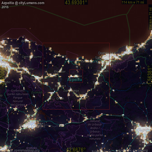
Analysis of Azpeitia night lights 2016
Square area 10x10 km:
 1.67%
1.67%90-99
2.73%80-89
1.67%70-79
2.42%60-69
1.21%50-59
0.91%40-49
0.3%30-39
0.61%20-29
0.91%10-19
2.73%0-9
84.85%Square area 50x50 km:
1.53%90-99
1.87%80-89
1.06%70-79
1.17%60-69
1.25%50-59
1.6%40-49
1.08%30-39
1.22%20-29
2.16%10-19
9.13%0-9
77.92%Clear (daylight) street map image can be seen on geolist.org.
Map coordinates:
43° 41' 34.8" North, 2° 58' 12.2" West
43° 10' 56.9" North, 2° 16' 0.9" West
42° 40' 3.4" North, 1° 33' 49.7" West
Some cities around Azpeitia sort by population:
• Zarautz
13.8 km =8.6 mi,  34°
34°
• Bergara
14.3 km =8.9 mi,  238°
238°
• Beasain
15.7 km =9.8 mi,  159°
159°
• Azkoitia
3.6 km =2.2 mi,  261°
261°
• Elgoibar
12.4 km =7.7 mi,  287°
287°
• Zumarraga
11.1 km =6.9 mi,  200°
200°
• Zumaia
12.5 km =7.8 mi,  5°
5°
• Deba
14.4 km =8.9 mi,  331°
331°
3129059 (p: 14,375)
Sources (retrieved 2019-11-25):
» Earth at Night: Flat Maps 2012, 2016