Lekeitio night lights from space
Night Light of Lekeitio (Basque Country) from space (Spain) Src. Average luminocity for 10x10km area is 4.5365% and for 50x50km: 7.5635%.
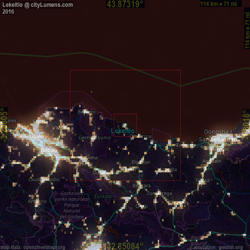
Analysis of Lekeitio night lights 2016
Square area 10x10 km:
 0%
0%90-99
0.95%80-89
0.32%70-79
0.16%60-69
1.11%50-59
0.63%40-49
1.59%30-39
0.32%20-29
1.9%10-19
0%0-9
93.02%Square area 50x50 km:
0.69%90-99
1.09%80-89
0.8%70-79
0.92%60-69
1.05%50-59
0.96%40-49
0.71%30-39
0.84%20-29
1.32%10-19
7.18%0-9
84.44%Clear (daylight) street map image can be seen on geolist.org.
Map coordinates:
43° 52' 23.5" North, 3° 12' 29" West
43° 21' 51" North, 2° 30' 17.7" West
42° 51' 3" North, 1° 48' 6.5" West
Some cities around Lekeitio sort by population:
• Eibar
20.1 km =12.5 mi,  172°
172°
• Bermeo
18.6 km =11.6 mi,  289°
289°
• Ermua
19.7 km =12.2 mi,  179°
179°
• Gernika-Lumo
15.4 km =9.6 mi,  249°
249°
• Elgoibar
18.1 km =11.2 mi,  155°
155°
• Ondarroa
8.9 km =5.5 mi,  126°
126°
• Zumaia
21.8 km =13.5 mi,  110°
110°
• Deba
14.5 km =9 mi,  121°
121°
3118523 (p: 7,254)
Sources (retrieved 2019-11-25):
» Earth at Night: Flat Maps 2012, 2016