Montornès del Vallès night lights from space
Night Light of Montornès del Vallès (Catalonia) from space (Spain) Src. Average luminocity for 10x10km area is 73.7449% and for 50x50km: 41.1978%.
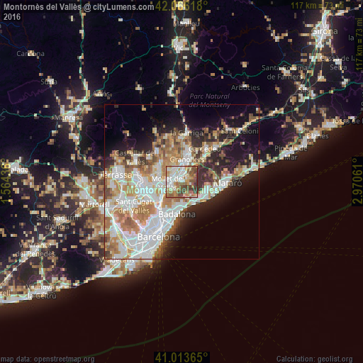
Analysis of Montornès del Vallès night lights 2016
Square area 10x10 km:
 15.65%
90-99
18.2%80-89
10.03%70-79
12.24%60-69
13.27%50-59
12.07%40-49
13.44%30-39
5.1%20-29
0%10-19
0%0-9
0%Square area 50x50 km:
10.64%90-99
9.63%80-89
4.11%70-79
5.35%60-69
7.08%50-59
4.82%40-49
3.62%30-39
3.52%20-29
6.47%10-19
10.83%0-9
33.94%Clear (daylight) street map image can be seen on geolist.org.
Map coordinates:
42° 3' 58.2" North, 1° 33' 51.7" East
41° 32' 31.4" North, 2° 16' 2.9" East
41° 0' 49.1" North, 2° 58' 14.2" East
Some cities around Montornès del Vallès sort by population:
• Mollet del Vallès
4.5 km =2.8 mi,  267°
267°
• Parets del Vallès
4.6 km =2.9 mi,  321°
321°
• La Llagosta
6.9 km =4.3 mi,  243°
243°
• La Roca del Vallès
7.1 km =4.4 mi,  50°
50°
• Alella
5.8 km =3.6 mi,  157°
157°
• Montmeló
2.3 km =1.4 mi,  292°
292°
• Tiana
6.7 km =4.2 mi,  180°
180°
• Teià
6.7 km =4.2 mi,  137°
137°
3116262 (p: 15,509)
Sources (retrieved 2019-11-25):
» Earth at Night: Flat Maps 2012, 2016