Montefrío night lights from space
Night Light of Montefrío (Andalusia) from space (Spain) Src. Average luminocity for 10x10km area is 1.5601% and for 50x50km: 4.7756%.
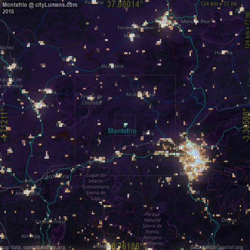
Analysis of Montefrío night lights 2016
Square area 10x10 km:
 0%
0%90-99
0.81%80-89
0.49%70-79
0%60-69
0%50-59
0%40-49
0.65%30-39
0%20-29
0%10-19
0%0-9
98.05%Square area 50x50 km:
0.15%90-99
0.58%80-89
0.8%70-79
0.57%60-69
0.74%50-59
0.67%40-49
0.69%30-39
0.95%20-29
0.93%10-19
2.35%0-9
91.6%Clear (daylight) street map image can be seen on geolist.org.
Map coordinates:
37° 52' 48.5" North, 4° 42' 43.6" West
37° 19' 23.1" North, 4° 0' 32.3" West
36° 45' 42.7" North, 3° 18' 21.1" West
Some cities around Montefrío sort by population:
• Priego de Córdoba
20.8 km =12.9 mi,  307°
307°
• Alcalá la Real
17.2 km =10.7 mi,  26°
26°
• Loja
21.3 km =13.2 mi,  216°
216°
• Santafé
29.7 km =18.5 mi,  120°
120°
• Pinos Puente
24.3 km =15.1 mi,  109°
109°
• Illora
12 km =7.5 mi, 109°
• Huétor-Tájar
14.3 km =8.9 mi,  193°
193°
• Castillo de Locubín
23.6 km =14.7 mi,  14°
14°
2513640 (p: 6,631)
Sources (retrieved 2019-11-25):
» Earth at Night: Flat Maps 2012, 2016