La Algaba night lights from space
Night Light of La Algaba (Andalusia) from space (Spain) Src. Average luminocity for 10x10km area is 55.2208% and for 50x50km: 26.777%.
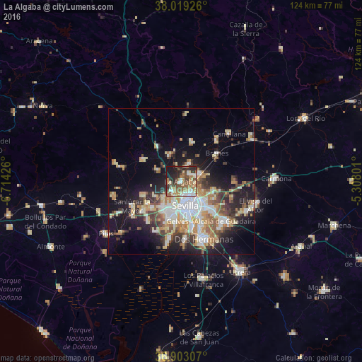
Analysis of La Algaba night lights 2016
Square area 10x10 km:
 7.63%
7.63%90-99
8.6%80-89
7.14%70-79
7.47%60-69
13.15%50-59
12.18%40-49
9.9%30-39
7.95%20-29
13.64%10-19
12.34%0-9
0%Square area 50x50 km:
4.78%90-99
4.28%80-89
4.06%70-79
3.54%60-69
4.35%50-59
2.94%40-49
3.04%30-39
4.34%20-29
5.6%10-19
12.74%0-9
50.32%Clear (daylight) street map image can be seen on geolist.org.
Map coordinates:
38° 1' 9.3" North, 6° 42' 51.3" West
37° 27' 47.7" North, 6° 0' 40.1" West
36° 54' 11.1" North, 5° 18' 28.8" West
Some cities around La Algaba sort by population:
• Sevilla
9.5 km =5.9 mi,  159°
159°
• La Rinconada
3.7 km =2.3 mi,  46°
46°
• Camas
7.1 km =4.4 mi,  195°
195°
• Castilleja de la Cuesta
9.3 km =5.8 mi, 203°
• Guillena
9.7 km =6 mi,  335°
335°
• Alcalá del Río
6.6 km =4.1 mi,  23°
23°
• Santiponce
4.1 km =2.5 mi,  220°
220°
• Valencina de la Concepción
7.6 km =4.7 mi,  226°
226°
2516217 (p: 14,942)
Sources (retrieved 2019-11-25):
» Earth at Night: Flat Maps 2012, 2016