Guillena night lights from space
Night Light of Guillena (Andalusia) from space (Spain) Src. Average luminocity for 10x10km area is 21.1006% and for 50x50km: 21.2925%.
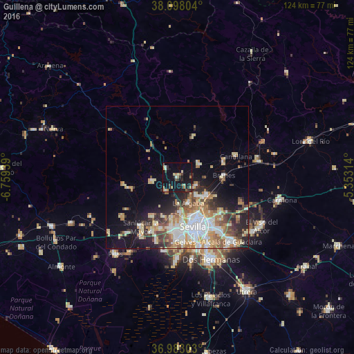
Analysis of Guillena night lights 2016
Square area 10x10 km:
 0.65%
0.65%90-99
1.95%80-89
3.73%70-79
2.11%60-69
4.22%50-59
1.14%40-49
2.76%30-39
2.92%20-29
6.98%10-19
27.27%0-9
46.27%Square area 50x50 km:
4.06%90-99
3.62%80-89
3.4%70-79
2.93%60-69
3.3%50-59
2.12%40-49
2.31%30-39
3.02%20-29
3.98%10-19
8.78%0-9
62.47%Clear (daylight) street map image can be seen on geolist.org.
Map coordinates:
38° 5' 52.9" North, 6° 45' 33.8" West
37° 32' 33.4" North, 6° 3' 22.5" West
36° 58' 58.9" North, 5° 21' 11.3" West
Some cities around Guillena sort by population:
• La Rinconada
9.1 km =5.7 mi,  133°
133°
• Camas
15.8 km =9.8 mi,  172°
172°
• La Algaba
9.7 km =6 mi,  155°
155°
• Brenes
16.3 km =10.1 mi,  87°
87°
• Alcalá del Río
7.1 km =4.4 mi,  112°
112°
• Santiponce
12 km =7.5 mi, 173°
• Valencina de la Concepción
14.1 km =8.8 mi,  186°
186°
• Gerena
8.8 km =5.5 mi,  260°
260°
2516855 (p: 11,109)
Sources (retrieved 2019-11-25):
» Earth at Night: Flat Maps 2012, 2016