Santiponce night lights from space
Night Light of Santiponce (Andalusia) from space (Spain) Src. Average luminocity for 10x10km area is 60.0812% and for 50x50km: 26.6407%.
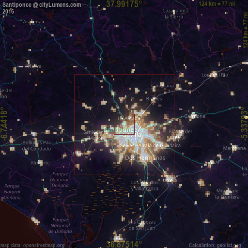
Analysis of Santiponce night lights 2016
Square area 10x10 km:
 13.15%
90-99
10.23%80-89
7.79%70-79
10.23%60-69
10.06%50-59
9.74%40-49
9.74%30-39
5.19%20-29
12.34%10-19
11.2%0-9
0.32%Square area 50x50 km:
4.72%90-99
4.19%80-89
3.97%70-79
3.57%60-69
4.29%50-59
2.95%40-49
2.99%30-39
4.28%20-29
5.45%10-19
13.15%0-9
50.44%Clear (daylight) street map image can be seen on geolist.org.
Map coordinates:
37° 59' 30.3" North, 6° 44' 39" West
37° 26' 7.9" North, 6° 2' 27.8" West
36° 52' 30.5" North, 5° 20' 16.5" West
Some cities around Santiponce sort by population:
• La Rinconada
7.7 km =4.8 mi,  43°
43°
• Camas
3.8 km =2.4 mi,  169°
169°
• Tomares
7 km =4.3 mi,  183°
183°
• Bormujos
7.4 km =4.6 mi,  201°
201°
• Castilleja de la Cuesta
5.6 km =3.5 mi,  190°
190°
• La Algaba
4.1 km =2.5 mi, 40°
• Gines
6.3 km =3.9 mi,  210°
210°
• Valencina de la Concepción
3.6 km =2.2 mi,  233°
233°
2511064 (p: 7,561)
Sources (retrieved 2019-11-25):
» Earth at Night: Flat Maps 2012, 2016