Iznalloz night lights from space
Night Light of Iznalloz (Andalusia) from space (Spain) Src. Average luminocity for 10x10km area is 1.2532% and for 50x50km: 6.5953%.
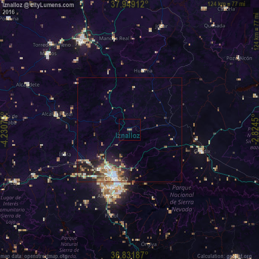
Analysis of Iznalloz night lights 2016
Square area 10x10 km:
 0%
0%90-99
0%80-89
0%70-79
0%60-69
0.81%50-59
1.14%40-49
0%30-39
0%20-29
0%10-19
0%0-9
98.05%Square area 50x50 km:
0.76%90-99
1.02%80-89
0.71%70-79
0.79%60-69
1.6%50-59
1.13%40-49
0.76%30-39
1.02%20-29
2.03%10-19
3.65%0-9
86.53%Clear (daylight) street map image can be seen on geolist.org.
Map coordinates:
37° 56' 56.8" North, 4° 13' 50.7" West
37° 23' 33.3" North, 3° 31' 39.4" West
36° 49' 54.7" North, 2° 49' 28.2" West
Some cities around Iznalloz sort by population:
• Granada
23.8 km =14.8 mi,  197°
197°
• Maracena
22.6 km =14 mi, 204°
• Albolote
21.2 km =13.2 mi,  212°
212°
• Atarfe
23.4 km =14.5 mi,  217°
217°
• Pinos Puente
25.2 km =15.7 mi,  231°
231°
• Huétor Vega
27.7 km =17.2 mi,  187°
187°
• Peligros
19.9 km =12.4 mi, 206°
• Cenes de la Vega
25.9 km =16.1 mi,  181°
181°
2516414 (p: 7,005)
Sources (retrieved 2019-11-25):
» Earth at Night: Flat Maps 2012, 2016