Güeñes night lights from space
Night Light of Güeñes (Basque Country) from space (Spain) Src. Average luminocity for 10x10km area is 18.2167% and for 50x50km: 17.8806%.
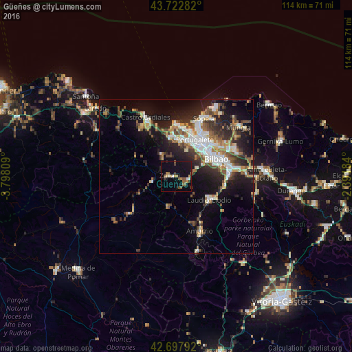
Analysis of Güeñes night lights 2016
Square area 10x10 km:
 0.3%
0.3%90-99
2.12%80-89
1.82%70-79
2.12%60-69
1.21%50-59
6.67%40-49
1.52%30-39
1.82%20-29
2.88%10-19
23.03%0-9
56.52%Square area 50x50 km:
2.94%90-99
3.32%80-89
1.71%70-79
1.82%60-69
2.25%50-59
2.77%40-49
2.17%30-39
2.92%20-29
5.21%10-19
11.16%0-9
63.73%Clear (daylight) street map image can be seen on geolist.org.
Map coordinates:
43° 43' 22.2" North, 3° 47' 53.1" West
43° 12' 45.1" North, 3° 5' 41.9" West
42° 41' 52.5" North, 2° 23' 30.6" West
Some cities around Güeñes sort by population:
• Barakaldo
12.7 km =7.9 mi,  42°
42°
• Portugalete
13.5 km =8.4 mi,  26°
26°
• Santurtzi
13.8 km =8.6 mi,  21°
21°
• Sestao
12.9 km =8 mi, 33°
• Erandio
14.2 km =8.8 mi, 43°
• Laudio / Llodio
13.2 km =8.2 mi,  125°
125°
• Ortuella
11.4 km =7.1 mi, 15°
• Zalla
3.9 km =2.4 mi,  306°
306°
3120998 (p: 6,147)
Sources (retrieved 2019-11-25):
» Earth at Night: Flat Maps 2012, 2016