Empuriabrava night lights from space
Night Light of Empuriabrava (Catalonia) from space (Spain) Src. Average luminocity for 10x10km area is 25.5303% and for 50x50km: 7.1183%.
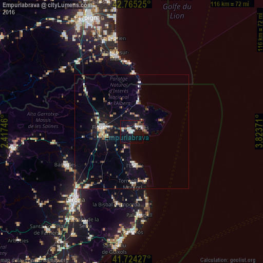
Analysis of Empuriabrava night lights 2016
Square area 10x10 km:
 6.67%
6.67%90-99
4.85%80-89
1.52%70-79
1.06%60-69
2.12%50-59
2.73%40-49
1.06%30-39
1.97%20-29
2.12%10-19
38.48%0-9
37.42%Square area 50x50 km:
0.9%90-99
0.98%80-89
0.65%70-79
0.62%60-69
0.89%50-59
0.91%40-49
1%30-39
1%20-29
1.14%10-19
5.96%0-9
85.95%Clear (daylight) street map image can be seen on geolist.org.
Map coordinates:
42° 45' 54.9" North, 2° 25' 2.9" East
42° 14' 48.9" North, 3° 7' 14.1" East
41° 43' 27.4" North, 3° 49' 25.4" East
Some cities around Empuriabrava sort by population:
• Figueres
13.3 km =8.3 mi,  279°
279°
• Roses
4.9 km =3 mi,  70°
70°
• Banyoles
32.6 km =20.3 mi,  243°
243°
• Castelló d'Empúries
4 km =2.5 mi,  286°
286°
• Torroella de Montgrí
22.7 km =14.1 mi,  178°
178°
• la Bisbal d'Empordà
33.5 km =20.8 mi,  190°
190°
• l'Escala
13.5 km =8.4 mi, 175°
• Banyuls de la Marenda, FR
26.3 km =16.3 mi,  1°
1°
3123473 (p: 8,000)
Sources (retrieved 2019-11-25):
» Earth at Night: Flat Maps 2012, 2016