Reocín night lights from space
Night Light of Reocín (Cantabria) from space (Spain) Src. Average luminocity for 10x10km area is 47.8397% and for 50x50km: 13.3078%.
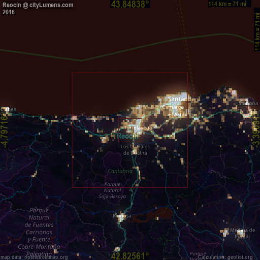
Analysis of Reocín night lights 2016
Square area 10x10 km:
 9.05%
9.05%90-99
9.37%80-89
7.46%70-79
3.97%60-69
9.05%50-59
9.05%40-49
3.97%30-39
4.92%20-29
10%10-19
24.6%0-9
8.57%Square area 50x50 km:
1.38%90-99
2%80-89
1.57%70-79
1.32%60-69
2.46%50-59
2.85%40-49
1.86%30-39
2.13%20-29
4.42%10-19
7.15%0-9
72.85%Clear (daylight) street map image can be seen on geolist.org.
Map coordinates:
43° 50' 54.2" North, 4° 47' 49.8" West
43° 20' 20.9" North, 4° 5' 38.5" West
42° 49' 32.2" North, 3° 23' 27.3" West
Some cities around Reocín sort by population:
• Torrelavega
3.9 km =2.4 mi,  72°
72°
• Camargo
18.5 km =11.5 mi, 65°
• El Astillero
23.2 km =14.4 mi, 72°
• Los Corrales de Buelna
8.6 km =5.3 mi,  168°
168°
• Santa Cruz de Bezana
19.3 km =12 mi,  52°
52°
• Cabezón de la Sal
12 km =7.5 mi,  253°
253°
• Suances
11.3 km =7 mi,  21°
21°
• Santa María de Cayón
21.1 km =13.1 mi,  99°
99°
3112008 (p: 7,230)
Sources (retrieved 2019-11-25):
» Earth at Night: Flat Maps 2012, 2016