Cervera night lights from space
Night Light of Cervera (Catalonia) from space (Spain) Src. Average luminocity for 10x10km area is 11.7825% and for 50x50km: 4.3616%.
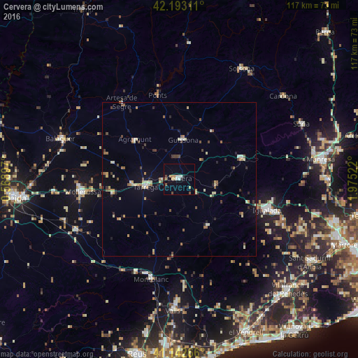
Analysis of Cervera night lights 2016
Square area 10x10 km:
 1.62%
1.62%90-99
1.62%80-89
0.97%70-79
2.76%60-69
0.81%50-59
0.97%40-49
1.62%30-39
0.65%20-29
0.97%10-19
0.16%0-9
87.82%Square area 50x50 km:
0.26%90-99
0.58%80-89
0.77%70-79
0.48%60-69
0.66%50-59
0.55%40-49
0.71%30-39
0.42%20-29
0.62%10-19
0.87%0-9
94.07%Clear (daylight) street map image can be seen on geolist.org.
Map coordinates:
42° 11' 35.2" North, 0° 34' 8.3" East
41° 40' 12.1" North, 1° 16' 19.6" East
41° 8' 33.6" North, 1° 58' 30.8" East
Some cities around Cervera sort by population:
• Igualada
30.3 km =18.8 mi,  109°
109°
• Balaguer
40.6 km =25.2 mi,  289°
289°
• Tàrrega
11.3 km =7 mi,  256°
256°
• Mollerussa
31.2 km =19.4 mi, 262°
• Vilanova del Camí
32.3 km =20.1 mi, 109°
• Montblanc
33.9 km =21.1 mi,  195°
195°
• Agramunt
19.5 km =12.1 mi,  311°
311°
• Capellades
37.8 km =23.5 mi, 114°
3125308 (p: 8,724)
Sources (retrieved 2019-11-25):
» Earth at Night: Flat Maps 2012, 2016