Beasain night lights from space
Night Light of Beasain (Basque Country) from space (Spain) Src. Average luminocity for 10x10km area is 25.8619% and for 50x50km: 8.921%.
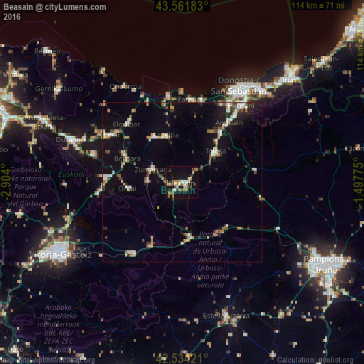
Analysis of Beasain night lights 2016
Square area 10x10 km:
 2.06%
2.06%90-99
4.44%80-89
1.75%70-79
5.08%60-69
4.29%50-59
6.35%40-49
1.43%30-39
3.02%20-29
1.11%10-19
29.52%0-9
40.95%Square area 50x50 km:
0.95%90-99
1.31%80-89
0.94%70-79
1.03%60-69
0.96%50-59
1.28%40-49
0.79%30-39
1.08%20-29
1.7%10-19
6.87%0-9
83.08%Clear (daylight) street map image can be seen on geolist.org.
Map coordinates:
43° 33' 42.6" North, 2° 54' 14.4" West
43° 3' 0.6" North, 2° 12' 3.1" West
42° 32' 3.2" North, 1° 29' 51.9" West
Some cities around Beasain sort by population:
• Tolosa
13.7 km =8.5 mi,  46°
46°
• Bergara
19 km =11.8 mi,  292°
292°
• Azpeitia
15.7 km =9.8 mi,  339°
339°
• Azkoitia
16.8 km =10.4 mi,  327°
327°
• Oñati
17.1 km =10.6 mi,  263°
263°
• Zumarraga
10.1 km =6.3 mi, 294°
• Altsasu
16.9 km =10.5 mi,  170°
170°
• Villabona
19.2 km =11.9 mi,  38°
38°
3128436 (p: 13,557)
Sources (retrieved 2019-11-25):
» Earth at Night: Flat Maps 2012, 2016