Zumarraga night lights from space
Night Light of Zumarraga (Basque Country) from space (Spain) Src. Average luminocity for 10x10km area is 14.4909% and for 50x50km: 11.0521%.
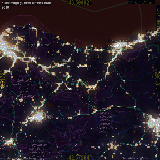
Analysis of Zumarraga night lights 2016
Square area 10x10 km:
 1.21%
1.21%90-99
1.82%80-89
1.82%70-79
1.67%60-69
1.52%50-59
1.06%40-49
3.03%30-39
1.67%20-29
3.33%10-19
2.42%0-9
80.45%Square area 50x50 km:
1.08%90-99
1.6%80-89
1.13%70-79
1.29%60-69
1.39%50-59
1.67%40-49
0.98%30-39
1.27%20-29
1.83%10-19
9.32%0-9
78.45%Clear (daylight) street map image can be seen on geolist.org.
Map coordinates:
43° 35' 59.7" North, 3° 1' 1.9" West
43° 5' 18.9" North, 2° 18' 50.7" West
42° 34' 22.6" North, 1° 36' 39.4" West
Some cities around Zumarraga sort by population:
• Arrasate / Mondragón
14.5 km =9 mi,  259°
259°
• Bergara
8.9 km =5.5 mi,  289°
289°
• Azpeitia
11.1 km =6.9 mi,  20°
20°
• Beasain
10.1 km =6.3 mi,  114°
114°
• Azkoitia
9.9 km =6.2 mi,  1°
1°
• Elgoibar
16.3 km =10.1 mi,  330°
330°
• Oñati
10 km =6.2 mi,  231°
231°
• Aretxabaleta
16.6 km =10.3 mi,  248°
248°
3104219 (p: 10,104)
Sources (retrieved 2019-11-25):
» Earth at Night: Flat Maps 2012, 2016