Anglès night lights from space
Night Light of Anglès (Catalonia) from space (Spain) Src. Average luminocity for 10x10km area is 11.3111% and for 50x50km: 11.2466%.
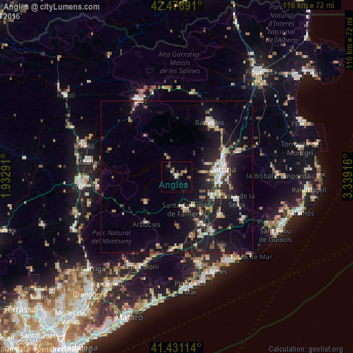
Analysis of Anglès night lights 2016
Square area 10x10 km:
 0.16%
0.16%90-99
2.38%80-89
0.63%70-79
0.63%60-69
3.02%50-59
2.7%40-49
1.27%30-39
1.43%20-29
1.43%10-19
0.63%0-9
85.71%Square area 50x50 km:
1.08%90-99
1.75%80-89
1.31%70-79
1%60-69
1.57%50-59
1.22%40-49
1.33%30-39
1.36%20-29
3.27%10-19
12.34%0-9
73.75%Clear (daylight) street map image can be seen on geolist.org.
Map coordinates:
42° 28' 36.9" North, 1° 55' 58.5" East
41° 57' 22.2" North, 2° 38' 9.7" East
41° 25' 52.1" North, 3° 20' 21" East
Some cities around Anglès sort by population:
• Girona
15.9 km =9.9 mi,  79°
79°
• Olot
27.7 km =17.2 mi,  334°
334°
• Salt
13.1 km =8.1 mi, 80°
• Banyoles
20.9 km =13 mi,  31°
31°
• Santa Coloma de Farners
10.3 km =6.4 mi,  165°
165°
• Sant Cristòfol de les Fonts
26.3 km =16.3 mi, 334°
• Cassà de la Selva
21.2 km =13.2 mi,  111°
111°
• Llagostera
25.7 km =16 mi,  123°
123°
3130032 (p: 5,159)
Sources (retrieved 2019-11-25):
» Earth at Night: Flat Maps 2012, 2016