Santa Coloma de Farners night lights from space
Night Light of Santa Coloma de Farners (Catalonia) from space (Spain) Src. Average luminocity for 10x10km area is 15.9778% and for 50x50km: 15.4252%.
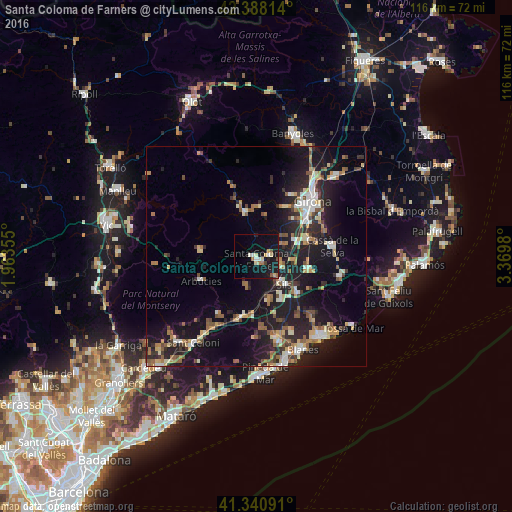
Analysis of Santa Coloma de Farners night lights 2016
Square area 10x10 km:
 1.43%
1.43%90-99
2.54%80-89
2.86%70-79
0.79%60-69
2.38%50-59
1.43%40-49
0.79%30-39
0.48%20-29
1.75%10-19
26.03%0-9
59.52%Square area 50x50 km:
1.43%90-99
2.3%80-89
1.97%70-79
1.59%60-69
2.07%50-59
2.29%40-49
1.72%30-39
1.94%20-29
5.27%10-19
16.09%0-9
63.32%Clear (daylight) street map image can be seen on geolist.org.
Map coordinates:
42° 23' 17.3" North, 1° 57' 48.8" East
41° 52' 0" North, 2° 40' 0" East
41° 20' 27.3" North, 3° 22' 11.3" East
Some cities around Santa Coloma de Farners sort by population:
• Girona
18.4 km =11.4 mi,  45°
45°
• Blanes
23.7 km =14.7 mi,  154°
154°
• Lloret de Mar
23.7 km =14.7 mi,  141°
141°
• Salt
15.9 km =9.9 mi,  40°
40°
• Tordera
19.1 km =11.9 mi,  166°
166°
• Cassà de la Selva
17.4 km =10.8 mi,  82°
82°
• Llagostera
19.3 km =12 mi,  103°
103°
• Anglès
10.3 km =6.4 mi,  345°
345°
3109982 (p: 11,739)
Sources (retrieved 2019-11-25):
» Earth at Night: Flat Maps 2012, 2016