Los Llanos night lights from space
Night Light of Los Llanos (San Pedro de Macorís) from space (Dominican Republic) Src. Average luminocity for 10x10km area is 0.9525% and for 50x50km: 8.4283%.
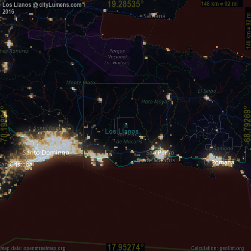
Analysis of Los Llanos night lights 2016
Square area 10x10 km:
 0%
0%90-99
0%80-89
0%70-79
0.83%60-69
0%50-59
0%40-49
0%30-39
0.83%20-29
0%10-19
0%0-9
98.35%Square area 50x50 km:
1.09%90-99
1.7%80-89
1.08%70-79
0.72%60-69
0.87%50-59
0.57%40-49
1.04%30-39
1.32%20-29
3.22%10-19
6.66%0-9
81.74%Clear (daylight) street map image can be seen on geolist.org.
Map coordinates:
19° 17' 7.3" North, 70° 11' 56.2" West
18° 37' 13.3" North, 69° 29' 44.9" West
17° 57' 9.9" North, 68° 47' 33.7" West
Some cities around Los Llanos sort by population:
• Santo Domingo Este
40.8 km =25.4 mi,  248°
248°
• San Pedro de Macorís
27.1 km =16.8 mi,  133°
133°
• Boca Chica
21.9 km =13.6 mi,  210°
210°
• Hato Mayor del Rey
29.7 km =18.5 mi,  57°
57°
• Bayaguana
20.6 km =12.8 mi,  314°
314°
• Quisqueya
11.7 km =7.3 mi, 128°
• Monte Plata
36.8 km =22.9 mi,  304°
304°
• El Valle
41.4 km =25.7 mi,  17°
17°
3498191 (p: 5,529)
Sources (retrieved 2019-11-25):
» Earth at Night: Flat Maps 2012, 2016