Zossen night lights from space
Night Light of Zossen (Brandenburg) from space (Germany) Src. Average luminocity for 10x10km area is 1.631% and for 50x50km: 13.2116%.
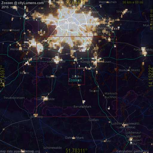
Analysis of Zossen night lights 2016
Square area 10x10 km:
 0%
0%90-99
0%80-89
0.53%70-79
0.53%60-69
0%50-59
0.53%40-49
0%30-39
0%20-29
0.53%10-19
0%0-9
97.88%Square area 50x50 km:
2.39%90-99
3%80-89
1.6%70-79
1.4%60-69
1.29%50-59
1.41%40-49
1.74%30-39
1.8%20-29
4.01%10-19
6.57%0-9
74.8%Clear (daylight) street map image can be seen on geolist.org.
Map coordinates:
52° 38' 41" North, 12° 44' 45.5" East
52° 12' 57.6" North, 13° 26' 56.7" East
51° 46' 59.2" North, 14° 9' 8" East
Some cities around Zossen sort by population:
• Königs Wusterhausen
15.7 km =9.8 mi,  52°
52°
• Ludwigsfelde
16.4 km =10.2 mi,  306°
306°
• Trebbin
15.3 km =9.5 mi,  270°
270°
• Rangsdorf
8.6 km =5.3 mi,  346°
346°
• Mittenwalde
7.9 km =4.9 mi, 51°
• Schulzendorf
18.8 km =11.7 mi,  32°
32°
• Großbeeren
18.5 km =11.5 mi,  329°
329°
• Bestensee
13.1 km =8.1 mi,  78°
78°
2803870 (p: 17,138)
Sources (retrieved 2019-11-25):
» Earth at Night: Flat Maps 2012, 2016