Wolfratshausen night lights from space
Night Light of Wolfratshausen (Bavaria) from space (Germany) Src. Average luminocity for 10x10km area is 7.2869% and for 50x50km: 9.0869%.
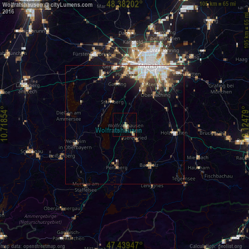
Analysis of Wolfratshausen night lights 2016
Square area 10x10 km:
 0%
0%90-99
0.43%80-89
2.98%70-79
0.57%60-69
0.28%50-59
1.99%40-49
1.14%30-39
0.99%20-29
1.56%10-19
0%0-9
90.06%Square area 50x50 km:
1.67%90-99
1.9%80-89
0.91%70-79
0.95%60-69
1.17%50-59
1.29%40-49
1.24%30-39
1.23%20-29
2.09%10-19
3.95%0-9
83.59%Clear (daylight) street map image can be seen on geolist.org.
Map coordinates:
48° 22' 55.3" North, 10° 43' 6.7" East
47° 54' 46.4" North, 11° 25' 18" East
47° 26' 22.1" North, 12° 7' 29.2" East
Some cities around Wolfratshausen sort by population:
• Geretsried
7.5 km =4.7 mi,  144°
144°
• Starnberg
11.5 km =7.1 mi,  329°
329°
• Grünwald
16 km =9.9 mi,  28°
28°
• Tutzing
10.5 km =6.5 mi,  267°
267°
• Pöcking
10.9 km =6.8 mi,  303°
303°
• Schäftlarn
9 km =5.6 mi,  16°
16°
• Dietramszell
14.8 km =9.2 mi,  118°
118°
• Egling
6.3 km =3.9 mi,  79°
79°
2806768 (p: 17,191)
Sources (retrieved 2019-11-25):
» Earth at Night: Flat Maps 2012, 2016