Egling night lights from space
Night Light of Egling (Bavaria) from space (Germany) Src. Average luminocity for 10x10km area is 2.8736% and for 50x50km: 10.3567%.
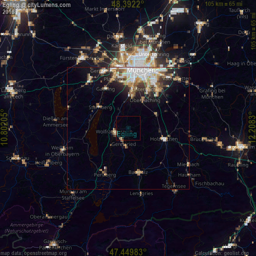
Analysis of Egling night lights 2016
Square area 10x10 km:
 0%
0%90-99
0%80-89
0.99%70-79
0.14%60-69
0%50-59
1.7%40-49
0%30-39
0.14%20-29
0.43%10-19
0%0-9
96.59%Square area 50x50 km:
2.06%90-99
2.17%80-89
1.05%70-79
1.07%60-69
1.29%50-59
1.38%40-49
1.31%30-39
1.45%20-29
2.19%10-19
4.65%0-9
81.39%Clear (daylight) street map image can be seen on geolist.org.
Map coordinates:
48° 23' 31.9" North, 10° 48' 7.4" East
47° 55' 23.4" North, 11° 30' 18.6" East
47° 26' 59.4" North, 12° 12' 29.9" East
Some cities around Egling sort by population:
• Geretsried
7.5 km =4.7 mi,  194°
194°
• Starnberg
14.8 km =9.2 mi,  306°
306°
• Wolfratshausen
6.3 km =3.9 mi,  259°
259°
• Oberhaching
13.2 km =8.2 mi,  31°
31°
• Grünwald
13 km =8.1 mi,  5°
5°
• Sauerlach
12.3 km =7.6 mi,  64°
64°
• Schäftlarn
8.3 km =5.2 mi,  333°
333°
• Dietramszell
10.7 km =6.6 mi,  140°
140°
2932992 (p: 5,061)
Sources (retrieved 2019-11-25):
» Earth at Night: Flat Maps 2012, 2016