Waldstetten night lights from space
Night Light of Waldstetten (Baden-Württemberg) from space (Germany) Src. Average luminocity for 10x10km area is 18.2173% and for 50x50km: 7.7232%.
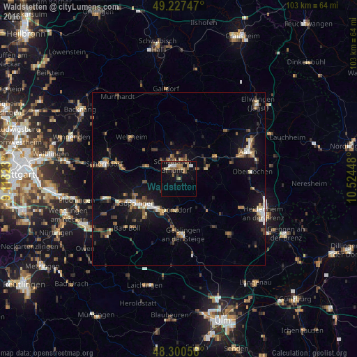
Analysis of Waldstetten night lights 2016
Square area 10x10 km:
 1.85%
1.85%90-99
2.13%80-89
1.42%70-79
2.13%60-69
2.7%50-59
4.26%40-49
2.56%30-39
2.41%20-29
2.7%10-19
14.91%0-9
62.93%Square area 50x50 km:
0.72%90-99
0.89%80-89
0.65%70-79
0.79%60-69
0.99%50-59
1.26%40-49
1.36%30-39
1.2%20-29
1.12%10-19
6.44%0-9
84.59%Clear (daylight) street map image can be seen on geolist.org.
Map coordinates:
49° 13' 38.9" North, 9° 7' 5.6" East
48° 45' 58.1" North, 9° 49' 16.9" East
48° 18' 2" North, 10° 31' 28.1" East
Some cities around Waldstetten sort by population:
• Schwäbisch Gmünd
4.1 km =2.5 mi,  335°
335°
• Eislingen
11.5 km =7.1 mi,  226°
226°
• Lorch
10.2 km =6.3 mi,  290°
290°
• Donzdorf
9 km =5.6 mi,  185°
185°
• Süßen
10.8 km =6.7 mi,  206°
206°
• Heubach
8.7 km =5.4 mi,  70°
70°
• Salach
10.3 km =6.4 mi,  216°
216°
• Mutlangen
6.9 km =4.3 mi,  345°
345°
2814775 (p: 7,316)
Sources (retrieved 2019-11-25):
» Earth at Night: Flat Maps 2012, 2016