Waldbüttelbrunn night lights from space
Night Light of Waldbüttelbrunn (Bavaria) from space (Germany) Src. Average luminocity for 10x10km area is 11.6845% and for 50x50km: 4.1735%.
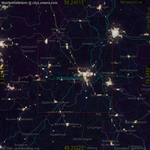
Analysis of Waldbüttelbrunn night lights 2016
Square area 10x10 km:
 0.8%
0.8%90-99
1.34%80-89
0.8%70-79
0.8%60-69
1.6%50-59
1.87%40-49
2.41%30-39
2.01%20-29
3.07%10-19
15.64%0-9
69.65%Square area 50x50 km:
0.51%90-99
0.69%80-89
0.39%70-79
0.33%60-69
0.5%50-59
0.62%40-49
0.69%30-39
0.64%20-29
0.84%10-19
2.89%0-9
91.89%Clear (daylight) street map image can be seen on geolist.org.
Map coordinates:
50° 14' 24.5" North, 9° 8' 36.7" East
49° 47' 18" North, 9° 50' 48" East
49° 19' 56.1" North, 10° 32' 59.3" East
Some cities around Waldbüttelbrunn sort by population:
• Würzburg
7.5 km =4.7 mi,  85°
85°
• Marktheidenfeld
18.6 km =11.6 mi,  289°
289°
• Veitshöchheim
5.5 km =3.4 mi,  26°
26°
• Höchberg
2.6 km =1.6 mi,  99°
99°
• Rimpar
11 km =6.8 mi,  46°
46°
• Zellingen
12.3 km =7.6 mi,  350°
350°
• Gerbrunn
10.6 km =6.6 mi, 97°
• Rottendorf
12.9 km =8 mi, 88°
2815127 (p: 5,099)
Sources (retrieved 2019-11-25):
» Earth at Night: Flat Maps 2012, 2016