Vellmar night lights from space
Night Light of Vellmar (Hesse) from space (Germany) Src. Average luminocity for 10x10km area is 38.4678% and for 50x50km: 4.7166%.
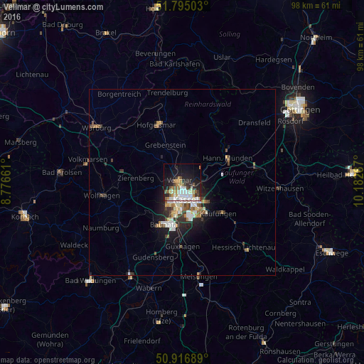
Analysis of Vellmar night lights 2016
Square area 10x10 km:
 7.84%
7.84%90-99
9.94%80-89
1.68%70-79
5.6%60-69
5.04%50-59
4.48%40-49
2.52%30-39
3.08%20-29
12.89%10-19
22.69%0-9
24.23%Square area 50x50 km:
0.74%90-99
1.1%80-89
0.31%70-79
0.56%60-69
0.57%50-59
0.61%40-49
0.54%30-39
0.62%20-29
1.37%10-19
2.99%0-9
90.58%Clear (daylight) street map image can be seen on geolist.org.
Map coordinates:
51° 47' 42.1" North, 8° 46' 35.8" East
51° 21' 29" North, 9° 28' 47.1" East
50° 55' 0.8" North, 10° 10' 58.3" East
Some cities around Vellmar sort by population:
• Kassel
4.8 km =3 mi,  162°
162°
• Baunatal
12.8 km =8 mi,  203°
203°
• Lohfelden
10.8 km =6.7 mi, 159°
• Fuldatal
6.7 km =4.2 mi,  65°
65°
• Calden
7.9 km =4.9 mi,  316°
316°
• Immenhausen
7.7 km =4.8 mi,  0°
0°
• Zierenberg
12.4 km =7.7 mi,  275°
275°
• Grebenstein
10.9 km =6.8 mi,  334°
334°
3207197 (p: 18,623)
Sources (retrieved 2019-11-25):
» Earth at Night: Flat Maps 2012, 2016