Fuldatal night lights from space
Night Light of Fuldatal (Hesse) from space (Germany) Src. Average luminocity for 10x10km area is 6.3824% and for 50x50km: 5.3526%.
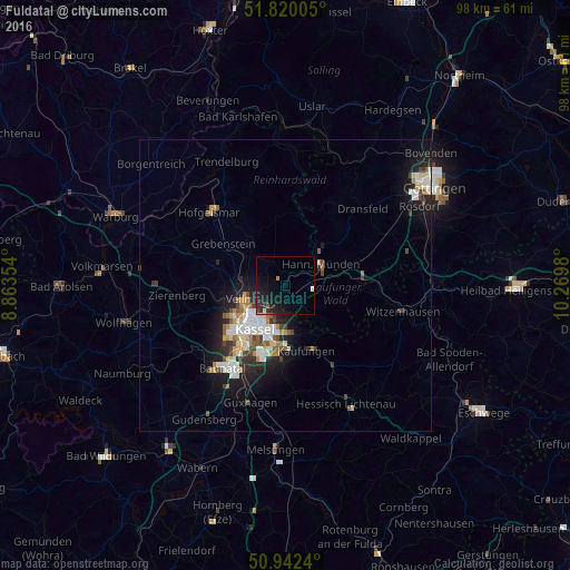
Analysis of Fuldatal night lights 2016
Square area 10x10 km:
 0.28%
0.28%90-99
0.84%80-89
0%70-79
0%60-69
0.56%50-59
0.42%40-49
0.7%30-39
0.98%20-29
5.32%10-19
11.06%0-9
79.83%Square area 50x50 km:
0.89%90-99
1.3%80-89
0.42%70-79
0.55%60-69
0.57%50-59
0.59%40-49
0.6%30-39
0.59%20-29
1.44%10-19
3.93%0-9
89.12%Clear (daylight) street map image can be seen on geolist.org.
Map coordinates:
51° 49' 12.2" North, 8° 51' 48.7" East
51° 22' 60" North, 9° 34' 0" East
50° 56' 32.6" North, 10° 16' 11.3" East
Some cities around Fuldatal sort by population:
• Kassel
8.7 km =5.4 mi,  211°
211°
• Hannoversch Münden
6.8 km =4.2 mi,  58°
58°
• Vellmar
6.7 km =4.2 mi,  245°
245°
• Lohfelden
13.2 km =8.2 mi,  190°
190°
• Kaufungen
11.9 km =7.4 mi,  162°
162°
• Calden
11.8 km =7.3 mi,  284°
284°
• Immenhausen
7.8 km =4.8 mi,  309°
309°
• Grebenstein
12.8 km =8 mi,  303°
303°
2923815 (p: 12,186)
Sources (retrieved 2019-11-25):
» Earth at Night: Flat Maps 2012, 2016